Producent: Admiralicja Brytyjska
ID: SC5610

|
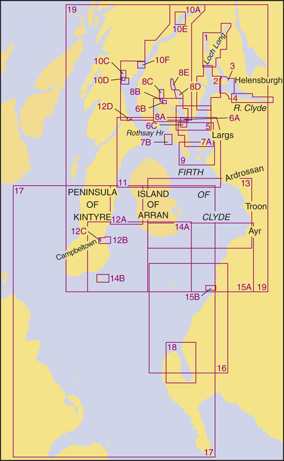
SC5610 The Firth of Clyde | 2nd Edition: 23/10/2008
|
| 5610.1 |
A Loch Goil and loch Long |
1:25,000 |
|
|
B Continuation of Loch Long |
1:25,000 |
| |
C Largs Yacht Haven |
1:12,500 |
|
|
D Milport |
1:12,500
|
|
5610.2
|
A Southern Approaches to Loch Long including Holy Loch |
1:25,000 |
| |
B Continuation of Loch Long |
1:25,000 |
| 5610.3 |
A Cartsdyke to Helensburgh |
1:15,000 |
| |
B Rhu Narrows |
1:12,500 |
| 5610.4 |
River Clyde |
|
| |
A Greenock Bank to Pilar Bank |
1:15,000
|
| |
B Pilar Bank to Dumbarton Castle |
1:15,000 |
| |
C Dumbarton Castle to Bowling |
1:25,000 |
| 5610.5 |
Inverkip to Rothesay |
1:25,000 |
| 5610.6 |
Plans in the Kyles of Bute |
1:25,000 |
| |
A Rothesay Bay |
1:10,000 |
| |
B Burnt Islands |
1:5,000 |
| |
C Rothesay Harbour |
1:2,500 |
| 5610.7 |
A Rothesay to Largs |
1:25,000 |
| |
B Inchmarnock Sound |
1:25,000 |
| 5610.8 |
A The Kyles of Bute |
1:25,000 |
| |
B Caladh Harbour |
1:10,000 |
| |
C Loch Riddon |
1:25,000 |
| |
D Central Loch Striven |
1:25,000 |
| |
E Upper Loch Striven |
1:25,000 |
| 5610.9 |
Largs to Farland Head and Garroch Head |
1:25,000 |
| 5610.10 |
A Loch Fyne |
1:75,000 |
| |
B Continuation of Loch Fyne |
1:75,000 |
| |
C Loch Gilp |
1:25,000 |
| |
D Ardrishaig |
1:10,000 |
| |
E Inveraray |
1:25,000 |
| |
F Loch Gair |
1:25,000 |
| 5610.11 |
Tarbert to Ardrossan |
1:75,000 |
| 5610.12 |
Plans on the Mull of Kintyre |
|
|
|
A Kilbrannan Sound
|
1:75,000
|
|
|
B Cambletown Loch
|
1:12,500
|
|
|
C Cambletown Harbour
|
1:5,000
|
|
|
D East Loch Tarbert
|
1:6,250
|
| 5610.13 |
Ardrossan to Pladda |
1:75,000 |
| 5610.14 |
A Kildonald Point to Ailsa Craig |
1:75,000 |
| |
B Sanda Island |
1:30,000 |
|
|
E Loch Gair
|
1:25,000
|
| 5610.15 |
A Pladda to Ailsa Craig and Ayr to Girvan |
1:75,000 |
| |
B Sanda Island |
1:30,000 |
| 5610.16 |
Ailsa Craig to Loch Ryan |
1:75,000 |
| 5610.17 |
North Channel and Approaches |
1:200,000 |
| 5610.18 |
A Loch Ryan |
1:25,000 |
| |
B Stranraer |
1:10,000 |
| 5610.19 |
Firth of Clyde |
1:200,000 |
|
|